[ad_1]
NEW DELHI: In an inversion of the normal rainfall pattern over the region, the adjacent states of Rajasthan and Uttar Pradesh find themselves at opposite ends of monsoon’s bounty this season. Rajasthan, normally among the driest states in the country, has so far logged nearly 60% more rain than its usually much wetter eastern neighbour.
This is the exact opposite of the climatological normal (the long period average or LPA) in the two states, as per which UP should have recorded 60% higher rainfall than Rajasthan during this period (June 1 to September 3).
The monsoon has been 42% above normal in Rajasthan so far, with the desert state recording 545.6mm of rain as against its normal of 384.1mm. Two-thirds of Rajasthan’s 33 districts (22) have reported excess or “large excess” (at least 60% higher than LPA) with no district logging deficient rainfall.
In stark contrast, neighbouring UP is staring at a drought, with the second highest monsoon deficiency among states of 44%.
![rain]()
This is the exact opposite of the climatological normal (the long period average or LPA) in the two states, as per which UP should have recorded 60% higher rainfall than Rajasthan during this period (June 1 to September 3).
The monsoon has been 42% above normal in Rajasthan so far, with the desert state recording 545.6mm of rain as against its normal of 384.1mm. Two-thirds of Rajasthan’s 33 districts (22) have reported excess or “large excess” (at least 60% higher than LPA) with no district logging deficient rainfall.
In stark contrast, neighbouring UP is staring at a drought, with the second highest monsoon deficiency among states of 44%.
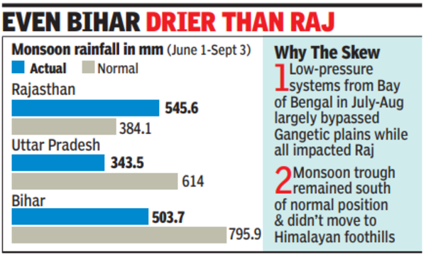
While Rajasthan had received 545.6mm of rain so far during the monsoon season, it’s neighbour, Uttar Pradesh, has recorded just 343.5mm against a normal of 614mm. Some 87% of the districts in UP – 65 out of 75 – have recorded deficient rainfall, 18 of which have a “large deficiency”, having received less than 40% of normal rains.
Two peculiar trends seen in this year’s monsoon caused this inversion of the normal rainfall pattern, said IMD chief Mrutyunjay Mohapatra. “One was the path followed by low-pressure wind circulations coming in from Bay of Bengal. All such systems that developed in July and August largely followed a similar path – moving in over Odisha, progressing through Chhattisgarh and MP before crossing into Rajasthan,” he said.
These moisture-laden cyclonic circulations, in the form of deep depressions, depressions or low-pressure systems, are a major source of monsoon rain in central India and adjoining regions. “Usually, some of these systems move northwards, causing rain in the Gangetic region. But such a movement did not take place at all in the last two months, except for the last one in late August. This was a deep depression that impacted Jharkhand, UP and Bihar, reducing the deficits there. It eventually moved to south Pakistan and interacted with local disturbances to cause massive rainfall and floods there,” Mohapatra said. On the other hand, the IMD chief added, each of these systems impacted Rajasthan, causing copious rains over the region.
“The second factor behind deficient rainfall in the Gangetic plains was the position of the monsoon trough – a belt of low pressure extending from east to west India along which there’s increased rainfall activity. The trough stayed mainly south of its usual position and didn’t move close to the Himalayas, which normally brings rain along the foothills and adjacent areas of the Gangetic plains,” Mohapatra said.
The two factors together skewed the rainfall pattern in north India, with all Gangetic states totting up big monsoon deficits even as the monsoon has been 5% above normal in the country so far. Apart from UP, Bihar has a monsoon deficit of 37%, Gangetic West Bengal 29% and Jharkhand 26%. Bihar, which normally receives twice as much average rainfall as Rajasthan, has recorded less rain than the western state thus far, totalling 503.7mm till September 3.
[ad_2]
Source link